
Earthquakes and natural disasters: when technology becomes a valuable ally in ‘predicting’ natural disasters
Although it is impossible to predict a disaster with any precision, there are solutions capable of detecting the first signs and alerting the public immediately

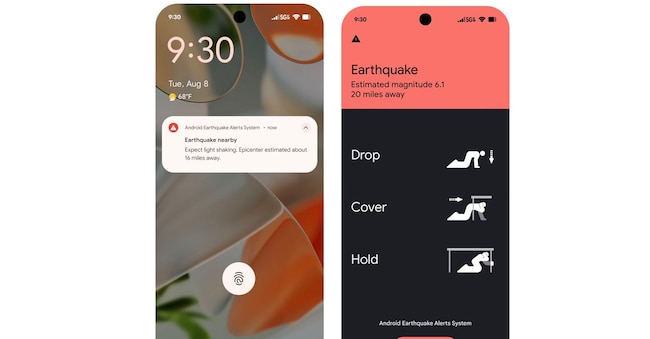
When an earthquake strikes, every second can make a difference. On the night of 24–25 June 2026, Venezuela was hit by the strongest earthquake in the last 126 years: two tremors, measuring 7.2 and 7.5 on the Richter scale, which occurred just seconds apart, caused casualties and significant damage. The South American country does not have a national early warning system; nevertheless, thousands of people with Android phones received an alert from the Android Earthquake Alerts system, which displayed a warning on their screens moments before the strongest tremors were felt by the population. The service is not capable of predicting an earthquake, nor does science have the tools to determine precisely when and where an earthquake will occur: so how did the phones manage to warn people in advance?
An earthquake generates waves that travel through the ground at different speeds: the first, known as P-waves, are less destructive and are felt in advance as slight tremors; these are followed by S-waves, which are often intense and cause more significant collapses or disasters. It is in this brief window of time between the first and second waves that technology can play its part by alerting the affected population. Google’s system turns smartphones into mini seismographs by using their built-in accelerometers; when several devices in the same area simultaneously detect movements consistent with an earthquake, they send anonymous signals to the servers: the algorithms compare the data, assess the location and intensity, and, if they detect a potential earthquake, send a notification to people who might be affected by the strongest waves. Unfortunately, although useful, the service is not available in Italia: on Italian Android devices, the section dedicated to alerts is visible but the service is disabled, so it is not possible to receive notifications in the event of an earthquake.
An alternative for Italians is IT-alert: the national public alert system, which does not require the installation of an app or registration with a service: in the event of serious emergencies or ongoing disasters, the service sends a message to mobile phones connected to mobile phone masts in the affected area, including those of people who are travelling or do not live in that area; the alert contains guidance on how to respond and does not rely on a data connection, as it uses broadcast transmission and continues to function even if the network is congested. It is worth noting that IT-alert is operational for specific scenarios such as nuclear or radiological incidents, industrial accidents, the collapse of large dams and volcanic activity in specific areas, whilst trials are still ongoing for tsunamis caused by earthquakes and heavy rainfall. For floods, severe storms, extreme temperatures and bad weather, the Civil Protection alert system remains the main point of reference: via the national portal, it is possible to consult bulletins and maps of expected risks, classified under yellow, orange and red alert levels. This is not a definitive prediction of damage but an indication of the expected risk in an area: a useful tool, particularly for those who need to travel, live near watercourses or reside in areas prone to landslides and flooding.
Alongside national services, many regions and local authorities have developed channels for issuing alerts: in Lombardy, there is the allertaLOM app, which allows users to receive alerts issued by the Civil Protection Agency, whilst in other areas, local authorities use apps, websites, Telegram channels, text messages and social media channels to report weather alerts, school closures or hazardous weather conditions. For earthquakes, the INGVterremoti app and the channels of the National Institute of Geophysics and Volcanology allow users to monitor events detected by the national network, providing information on the time, magnitude and epicentre: they do not predict the tremor but help to distinguish verified data from unconfirmed reports. In conclusion, technology is no substitute for prevention or self-protection measures, but it can provide timely information and, in the most critical situations, give you a few seconds or minutes’ warning that can make all the difference.

