
Gaza, a year and a half of destruction as seen from satellites
Images of the Strip from space show the destruction of 90% of the building structures
3' min read
3' min read
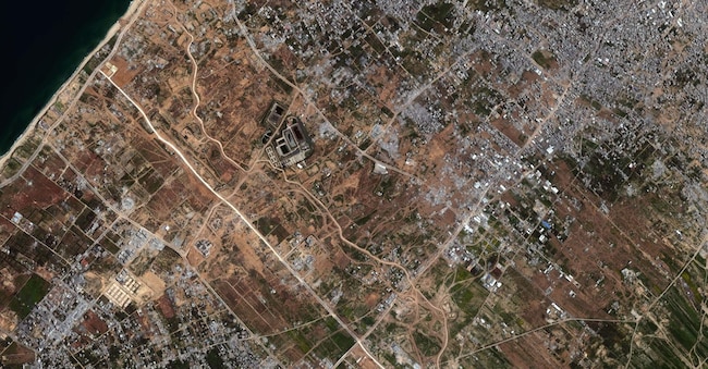
From space, Gaza has become a blurred blur of grey and dust. Up-to-date satellite images show almost total devastation: neighbourhoods obliterated, roads disappearing, buildings reduced to piles of rubble. According to the UN, 90 per cent of the building structures in the Strip have been destroyed or damaged; other sources speak of 70 per cent, with 92 per cent of the housing capacity obliterated.
The conflict began on 7 October 2023 with the Hamas attack on Israel, which was followed by an unprecedented military response. Israel declared a state of war the following day, initiating carpet bombings and a ground invasion. Since then, the Strip has been the scene of a prolonged and intensive offensive that has radically transformed the territory.
Satellite images from Google Earth and Planet Labs document the dramatic transformation of the region. In Rafah, in the south of the Strip, entire neighbourhoods - such as Tal as-Sultan, Shaboura and the refugee camp of the same name - have been razed to the ground, leaving only sand and debris. In Gaza City, the residential areas of al-Rimal and Sheikh Radwan were almost completely obliterated, along with key civilian infrastructure such as the Islamic University and Al-Shifa Hospital, the largest in the Strip. Drone and aerial footage show a reality similar to an urban wasteland.
Projects such as Forensic Architecture's A Cartography of Genocide have mapped over 2,000 Israeli attacks, highlighting a systematic campaign of destruction of vital infrastructure: schools, hospitals, water plants, power plants. The group also denounced cases in which the Israeli government presented altered or misleadingly labelled images, for example by falsely attributing an airstrike crater to a rocket launch from a civilian structure.
The health system has been practically wiped out. According to the World Health Organisation, 94% of hospitals have been affected. On 30 May 2025, the Al-Awda hospital, the last operational one in northern Gaza, was evacuated after two weeks of siege. Also affected were the Kamal Adwan in Beit Lahia, the Indonesian medical complex in Jabalia and several mobile clinics.

