Digital Economy

Google removes AI from Earth: when satellite deepfakes undermine trust in maps

The ability to generate artificial images directly on Google Earth lasted less than a day

3' min read

Translated by AI
Versione italiana

3' min read

Translated by AI
Versione italiana

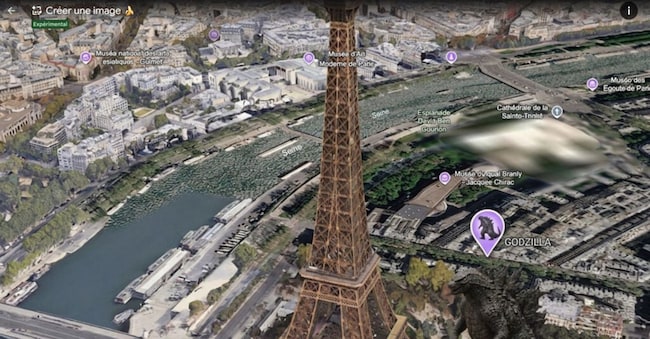
Perhaps even a child would realise that the image of Godzilla about to destroy the Eiffel Tower is a fake, generated by AI. The images of a military attack on the Iranian island of Kharg – a sign of a possible, much-discussed American invasion – are, however, a completely different matter. And if these images appear to come from a satellite, the risk of disinformation becomes extremely high. So it took less than a day for Google to withdraw this feature from Google Earth – the one that allowed users to generate artificial satellite images directly on the map of the planet with a simple prompt: all you had to do was select a location, click on ‘Create image’ and describe what you wanted to see.

Fiction and reality merge in a tool that, until then, had been the very epitome of objectivity: satellite imagery. In an age of social media disinformation, what on earth could possibly go wrong?

Loading...

Strange as it may seem, Google hadn’t considered the consequences, but it soon saw them in the form of a deluge of satellite deepfakes. The US Capitol submerged by a flood. Nuclear power stations, hospitals, airports and international borders transformed into scenes of war or disaster.

Google has therefore suspended the feature.

“We have seen professionals in the geospatial sector use this feature for a range of useful purposes,” Google said in a statement. “However, we have also noticed that some people are sharing screenshots of generated images that appear to breach our policies. We are therefore disabling this feature on Google Earth whilst we work on implementing stricter controls.”

Experts and analysts who rely on Google Images to verify the latest news and atrocities in hard-to-reach parts of the world were immediately taken aback by this feature.

In recent years, satellite imagery has in fact become one of the most important tools of open-source intelligence (OSINT). Organisations such as Bellingcat, investigative journalists, academic researchers and even governments use it to verify air strikes, military movements, fires, natural disasters and human rights violations.

During the war in Ukraine, they made it possible to document the advance of Russian troops and the destruction of civilian infrastructure. In the Gaza conflict, they are used on a daily basis to compare images circulating on social media with the actual condition of buildings. In Myanmar, Sudan and Syria, they are often one of the few independent sources available when journalists are denied access to the ground.

The reason is simple: although satellite imagery is neither perfect nor always up to date, it is captured by sensors operated by professional staff and, to date, has been extremely difficult to manipulate in a credible way.

With this new feature in Google Earth, that assumption changed radically.

Loading...

An image showing a non-existent fire at an oil refinery, a collapsed bridge, a sunken aircraft carrier or a destroyed airport could be shared on social media as if it were a normal Google Earth screenshot. Its credibility would stem not so much from the image itself as from the authority of the source from which it appears to originate.

A false report of a fire at an oil terminal could affect energy markets in the hours immediately following the news. An image of a commercial port that appears to have been destroyed could alter the expectations of logistics operators. A non-existent flood in an urban area could trigger panic, evacuations or financial speculation before a denial is issued.

Artificial intelligence does, in fact, drastically reduce the cost of producing this content. What until recently required specialist software and graphic design skills can now be achieved with just a few words.

Google has pointed out that the images generated are marked with the SynthID digital watermark and that filters are in place to prevent the most dangerous uses.

But many experts believe that the problem runs deeper than that.

As Henk van Ess, a researcher specialising in OSINT, has observed, the paradox is that “the fake is created within the very tool used to verify whether an image is genuine”.

This incident is probably one of the first instances in which a major artificial intelligence provider has withdrawn a feature, not because of technical errors, but because it compromises the reliability of an information infrastructure deemed essential.

It is a lesson that goes beyond Google. These are the tools that serve as a reference point for citizens, journalists, businesses and institutions as they seek to distinguish facts from manipulation.

If these tools, too, become generators of alternative realities, the whole system of trust linked to primary sources of information is thrown into crisis.

Copyright reserved ©
Loading...

Brand connect

Loading...

Newsletter

Notizie e approfondimenti sugli avvenimenti politici, economici e finanziari.

Iscriviti