
Infrared satellites to monitor methane leaks
Images of MethaneSat were released in Baku. Useful for acting on gas leaks that contribute to emissions
3' min read
Key points
3' min read
When the Nord Stream pipeline between Russia and Germany was damaged by a mysterious explosion in 2022, the methane leaks were so great that the naked eye could see the sea bubbling with gas. GhgSat took the opportunity to release an image of the gigantic methane plume recorded from space with the infrared eye of its satellites and thus demonstrate the validity of its technology for detecting emissions of this very powerful greenhouse gas.
How is methane detected?
.Until recently, there was no clear picture of methane leaks around the world. There were no dedicated satellites and scientists used alternative satellite systems, such as the Tropomi instrument on board the Copernicus Sentinel-5P satellite, to detect methane leaks. Now a new generation of satellites is filling important gaps in the world's detection system, using infrared sensors, which record methane traces in the atmosphere by observing the way the gas absorbs reflected sunlight from the Earth's surface. In 2023, GhgSat detected methane equivalent to 0.5 billion tonnes of CO₂, double the level discovered the previous year.
Loading...
GhgSat serving oil companies
.A world leader in monitoring greenhouse gas emissions from space, GhgSat has the largest constellation of commercial satellites capable of detecting methane and carbon dioxide emissions at high resolution. It has 12 satellites in orbit, with which it monitors emissions for its hydrocarbon and mining customers, as well as governments, and shares its data with NASA and the European Space Agency. Founded and run by Stéphane Germain, the Montreal-based company is growing rapidly: its revenues increased from a few hundred thousand dollars in 2019 to $20 million last year. Its clients include the Oil and Gas Climate Initiative's takeover programme, which includes 12 oil giants (including Eni), thanks to which three major leaks in Kazakhstan and Algeria were plugged in 2023, according to the latest Ogci report.
The Transparency Incentive
.Leaks from old plants are a major problem, not only in developing nations, which are targeted by the Ogci programme, but also in rich countries such as the United States, which is the world's largest emitter of methane, followed by Russia and Iran. The report does not reveal the names of the operators responsible for the leaks, arguing that it is crucial to build trust rather than blame. Not everyone, however, agrees with this approach. Andrew Baxter, energy director of the Environmental Defense Fund, recognises the importance of the Ogci programme, which combines satellite tracking with peer-to-peer engagement and financial support to tackle emissions. "But I think transparency is a huge incentive to act," comments Baxter, who wants to ensure full transparency on who is responsible for the leaks detected by MethaneSat, the satellite launched in March by the US environmental NGO.
The collaboration between Google and MethaneSat
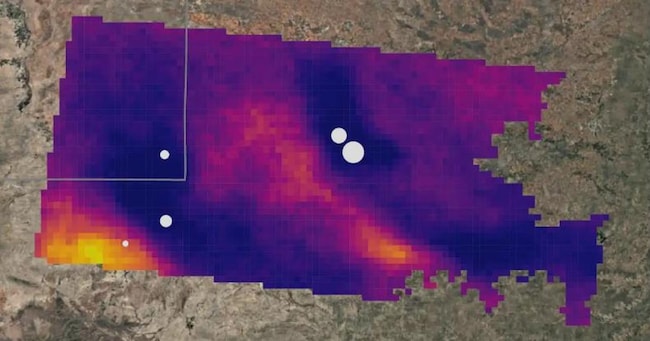
.Costing $88 million, MethaneSat is designed to measure methane leaks that other satellites cannot detect, looking for them where other detection systems are not looking. It can calculate total leaks, where they come from and how they change over time, providing a tool for regulators preparing to impose financial penalties on leaky infrastructure. Other satellites, according to the American NGO, offer high spatial resolution or wide coverage. 'MethaneSat is the first satellite of its kind to offer the best of both worlds, both in terms of spatial coverage and emissions sensitivity,' argues Patrick Barker, analyst at Wood Mackenzie. The project, which has also secured Google's endorsement, can detect emissions of up to 500 kg per hour from areas as small as one square kilometre, simultaneously scanning a field of view 200 km wide. Google, for its part, provides the artificial intelligence-based processing capabilities needed to process the massive amounts of data produced by the methane detector in orbit. The collaboration with Google allows the MethaneSat team to use Google Cloud, AI, mapping and satellite imagery to provide the first comprehensive map showing how different types of machinery contribute to methane leaks over time. 'By the end of 2025 we should have a very clear picture on a global scale from major oil and gas reservoirs around the world,' said Steven Hamburg, the company's chief science officer. This will be the first step towards cleaning up.
Copyright reserved ©


Brand connect
Loading...
