
The last flight of the Vega rocket takes the new Copernicus programme satellite into orbit
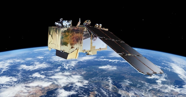
It is the third Sentinel-2 satellite launched yesterday aboard the latest Vega rocket from the European spaceport in French Guiana
2' min read
2' min read
One more piece in the Copernicus programme (the leading Earth observation programme) for the fight against climate change and global environmental challenges. And a series of activities ranging from supporting agriculture to monitoring water quality and managing natural disasters. It is the third Sentinel-2 satellite (Sentinel-2 satellites were designed and built by a consortium of some 60 companies, led by Airbus Defence and Space), launched yesterday aboard the latest Vega rocket from Europe's spaceport in French Guiana, which "will continue to provide high-resolution data essential for Copernicus.
The Milestone
."This mission further confirms the role of Copernicus as a flagship programme in the fight against climate change and in addressing global environmental challenges," emphasises Simonetta Cheli director of ESA's Earth Observation Programmes, "while ensuring the continuity of data that is essential to support agriculture, forestry, maritime monitoring and many other sectors. Together, we are strengthening Europe's commitment to a sustainable future, providing decision makers with the tools they need to protect our planet'. For the director, this is a 'new milestone in the well-established collaboration between Esa and the European Commission'. Costantin Mavrocordatos, Project Manager of Sentinel-2 at Esa, also agrees, speaking of a success made possible "thanks to the dedication and hard work of our extraordinary team. Together, we have taken another decisive step in the advancement of Earth observation and in the support of applications that are crucial for the protection of our planet'.
High-resolution images
.The Copernicus Sentinel-2 mission provides high-resolution optical images for a wide range of applications, including land, water and atmospheric monitoring. The mission, Esa officials explain, is based on a constellation of two identical satellites orbiting in the same path but spaced 180° apart: Sentinel-2A and Sentinel-2B. Together, they cover all of Earth's land and coastal waters every five days.
A wide range of applications
.Sentinel-2 data is currently being used for a wide range of applications, including agriculture, water quality monitoring and natural disaster management, including fires, volcanic eruptions and floods. "The mission," they point out at Esa, "has exceeded initial expectations, demonstrating, for example, its ability to detect methane emissions.
Agriculture Support
.For agriculture, the mission 'helps monitor crop health, predict yields and facilitate precision agriculture'. The images are used to identify crop type and determine biophysical variables such as leaf area index, chlorophyll content and leaf water content to monitor plant growth and health.

