
Not only Niscemi, 94% of municipalities are at risk from landslides, floods and avalanches
Through the Idrogeo platform, developed by Ispra and easily consulted from a smartphone, it is possible to monitor the state of hazards and landslides in the national territory
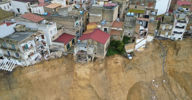
The most 'notorious' is the one in Niscemi: a landslide with a front of 4 kilometres and a ground subsidence of tens of metres. But the landslide that hit Sicily is not the only one, as more than 648,000 have been recorded throughout the country. Evolving numbers contained in the Iffi, Ispra's landslide phenomena inventory, which contains all the files relating to landslides surveyed by the Higher Institute for Environmental Protection and Research, through the Idrogeo platform.
The case of Niscemi
And the municipality of Niscemi, as the Ispra researchers point out, 'is historically affected by landslides, as reported by the Inventory of Landslide Phenomena in Italy'.
"The landslide that hit Niscemi in Sicily last 25 January is affecting the built-up area near the Sante Croci district and the provincial road SP10," the Ispra researchers write. The built-up area of Niscemi lies on a plateau bordered by an escarpment near and on the edge of the built-up area. The outcropping soils consist of sands with sandstone levels, resting on clays'. This is not an isolated case, since 'the Sante Croci area had already been hit on 12 October 1997 by a landslide of vast proportions', on which the Region's geologists are continuing to work on mapping and updating the Iffi inventory.
The Hydrogeo Platform
The main landslide events, as well as the damage to buildings, cultural heritage, primary communication infrastructures, and the economic and productive fabric, are recorded on a daily basis by Ispra researchers, in cooperation with the Regions and Autonomous Provinces. All data then end up in the national IdroGEO platform, a tool that is 'easy to use even with a smartphone'.
By connecting to the platform, one can learn about the state of places, from hazard to landslides, throughout Italy. With "Hazard Check", the user can search for an address, or geolocalise on a map and identify the hazard level for landslides and floods within a 500-metre radius of the point of interest (home, business or production activity).

