The cycle traveller

On the high-altitude military roads between Italia and France

The Assietta, Sale or Cannoni Route: cycling through the border valleys along high-mountain military trails between the Turin and Cuneo areas. Mule tracks and spartan mountain huts where grand history intersects with the stories of small border trades

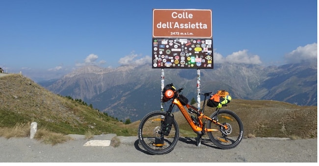
Colle dell’Assietta

6' min read

Translated by AI
Versione italiana

6' min read

Translated by AI
Versione italiana

It is a paradise for high-altitude cycle touring. Here, you cycle at altitudes of over 2,000 metres, up to 2,600 metres and beyond. Sometimes above the clouds. The view stretches across half the Alpine arc, offering 360-degree panoramas in an area where, on clear days, the vista can extend from Monte Rosa all the way to Corsica.

The adjective ‘breathtaking’ is no hyperbole. It accurately describes the sense of ecstatic wonder that a cycle tourist might feel when faced with such majestic landscapes.

Loading...

We’re in Piedmont, in the Western Alps, where an extensive network of high-altitude military roads offers cycling enthusiasts an extraordinary playground. You can forget about the overcrowding that has long plagued the Dolomites. There’s no sign of it round here. At least for now.

Alpine huts are spartan. At mealtimes, thankfully, there’s no need for oysters and champagne, but rather a plate of local polenta or ‘acciughe al verde’. It is the raw ingredients that, over the centuries, Ligurian fishermen have brought up here, clambering along the mule tracks – the first part of this magnificent network of roads.

Blood and cannon fodder

The Assietta Road, the Via del Sale and the Strada dei Cannoni: these are just a few of the names associated with this vast historical and landscape heritage, which has survived to the present day in good condition. They wind their way through the Upper Chisone Valley, the Upper Susa Valley and the Upper Maira Valley in the provinces of Turin and Cuneo, forming part of a complex defensive system comprising forts and, later, bunkers, designed to guard the mountain passes potentially exposed to the risk of enemy invasion.

In fact, it is not just the landscapes that make these areas unique. These places are steeped in the history of the Old Continent. And it is a history stained by wars and conflicts, one that tells of rivalries, mistrust between large and small states, diplomatic manoeuvring and about-turns.

Whereas today cyclists happily ride their state-of-the-art bikes – whether powered by muscle or (increasingly) by electric assistance – in centuries past young people were sent to their deaths as cannon fodder in the service of the ambitions of the monarchies to which they were subjects.

And here, a reflection is in order: the more than eighty years of peace that European integration – for all its flaws – has bestowed upon no fewer than three generations is an extraordinary gift, unprecedented in our history, which must be preserved for the benefit of future generations.

Centuries of mistrust and shared interests

In these mountains, the House of Savoy and the Kingdom of France have been at loggerheads for hundreds of years. The border along the ridges of the Cottian Alps has been disputed since at least the early 18th century, shifting slightly further east or slightly further west depending on geopolitical developments. In 1800, during his second Italian campaign, Napoleon crossed the Alps via the Great St Bernard Pass and from there descended rapidly into the Aosta Valley and invaded Piedmont.

But there had been skirmishes and military clashes even before that. At the top of the Strada dell’Assietta, at an altitude of almost 2,600 metres, a small obelisk commemorates the battle of 1747. The War of the Austrian Succession was raging. Maria Theresa was due to ascend the throne in Vienna. But France, Spain and Prussia were opposed to this. England sided with Austria, as did Charles Emmanuel III of Savoy. The French army attempted to break through the Piedmontese defensive line, but the Savoyard troops managed to repel the enemy, despite the latter having an overwhelming numerical superiority.

Loading...

A due ruote sulle strade militari alpine

Photogallery25 foto

A century later, the situation had changed. Napoleon III’s France viewed the unification of Italia, led by the House of Savoy, with favour. The aim was to weaken the Austro-Hungarian Empire, Paris’s historic arch-rival.

Then, in the 1930s, the situation changed once again. Fascist Italia began to perceive France as a threat once more and felt the need to create the Western Alpine Barrier, a defensive line consisting of forts, bunkers and military roads. The Assietta Road as we know it today is the result of the reorganisation carried out by the Military Engineering Corps in 1937–1938.

Starting from the Alpine Wall in 1940, following our country’s entry into the Second World War, troops of the Royal Italian Army launched an attack on France, which ultimately ended in a substantial failure.

Wednesday or Saturday – which is better?

Today, its military significance has given way to its appeal as a tourist destination. The Strada dell’Assietta is the perfect destination for cyclists looking to treat themselves. Thirty-six kilometres of gravel road in perfect condition. But be warned: in summer, to get the most out of the Assietta, it’s best to plan your ride for a Wednesday or Saturday.

These are the two days of the week in July and August when the road is closed to all motorised vehicles. So, no cars, no motorbikes and no roar of engines to shatter the silence of the mountains.

The cycle route can be planned in several ways. One starting point is Balboutet, a small mountain village and hamlet of Usseaux – one of the most beautiful municipalities in our country and a recipient of the Touring Club’s ‘Bandiera Arancione’ award – in Occitania, the border region between Italia and France.

From Balboutet, at an altitude of 1,500 metres, you cycle for a few kilometres along a tarmac road up to Pian dell’Alpe (1,900 metres) and on to the charming Lago delle Rane. From there, the winding, unpaved uphill road begins. It is cycling bliss in its purest form.

The road was originally built as a military road. As such, the gradients are gentle and not particularly challenging. The route is suitable for mountain bikes, e-MTBs and gravel bikes. Road bikes should be avoided.

The technical difficulty is very low. If you’re cycling manually, a reasonable level of fitness is required. But on an e-bike, the route is (almost) suitable for everyone. The only caveat is the altitude. As the route climbs to an altitude of 2,600 metres, the exertion is obviously not recommended for those with heart conditions.

The bulk of the climb ends at the small obelisk commemorating the Battle of Assietta, in which General Armand Fouquet, leader of the French forces, was killed. Next, a must-visit is the Casa Assietta “Jack Canali” mountain refuge, converted from a former military barracks dating from the 1890s, situated at an altitude of 2,500 metres in the Bosco di Salbertrand Nature Park. Here you can enjoy traditional local dishes, stay overnight and, for those who need to, recharge your e-bike batteries.

The road continues at altitude through a gently undulating, almost flat area. It passes beneath various hills and overlooks Sauze d’Oulx (Salice d’Ulzio). The Via Lattea runs through this area; with around 400 kilometres of slopes, it becomes one of the largest ski areas in the Alps during the winter.

In Sestriere with the star architect

Then comes the magnificent descent towards Sestriere, at an altitude of 2,050 metres – the highest municipality in Italia and the first example in Europe of a ski resort that did not develop from a pre-existing Alpine village, but was instead designed from scratch, starting with the green pastures.

The silhouette of the two reinforced concrete towers is unmistakable. Architectural forms that might make us turn up our noses today. But in 1932–1933, when they were designed and built on the initiative of the Agnelli family, they were futuristic forms, designed by a star architect of the time, Vittorio Bonadé-Bottino, Fiat’s trusted architect and a pupil of Giacomo Matté-Trucco, who designed the Lingotto in Turin.

On the Balboutet route, the elevation gain is around 1,400 metres. Starting from Sestriere, however, the climb is shorter.

A ‘tailor-made’ cycle tour

The route for the Assietta is available online. However, for those unfamiliar with the area, it is also worth considering hiring a local cycling guide. This turns the ride into a historical and cultural journey, making the cycling experience all the more enriching.

The tour described here was, in fact, conceived as a ‘bespoke’ cycling holiday, tailor-made by a local guide. There are several such guides in the area. Among them is Mauro Casarone, accredited by the Piedmont Region, who has ‘tailored’ an itinerary to suit the client’s requirements: number of days, distance, maximum elevation gain per stage, and manageable level of difficulty.

The result was a three-day tour taking in Balboutet, Sestriere and Cesana Torinese, which, venturing into France, took in not only the Assietta but also the ‘Monti della Luna’, the old green marble quarries above Cesana, the magnificent Lago Nero – the iconic highlight of this tour – and the Lago dei sette colori.

What can I say? It’s marvellous! And as the appetite comes with eating, it goes without saying that – if you haven’t already done so – the Via del Sale from Limone Piemonte to the sea at Ventimiglia and the Strada dei Cannoni in the Upper Maira Valley should be at the top of your to-do list. Enjoy your rides!

Copyright reserved ©
Loading...

Brand connect

Loading...

Newsletter

Notizie e approfondimenti sugli avvenimenti politici, economici e finanziari.

Iscriviti

Tutto mercato WEB