Space

Satellites, dual use exposes the lies of war

Iranian agencies released images of Chinese satellites, revealing the damage done to the US

by Leopoldo Benacchio

3' min read

Translated by AI
Versione italiana

3' min read

Translated by AI
Versione italiana

Heaven forbid, this is also part of the result of the war between the US and Iran, and there is much to learn. The fact that people lie a bit in these situations, like fishermen who, if they catch a 10 centimetre fish, tell it as a half-metre shark, has been known since the times of the wars between the Assyrians and the Babylonians. Today, however, thanks to satellite technology, the truth is coming out.

The Washington Post Inquiry

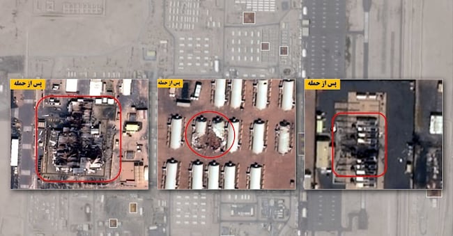
This is the lesson from a multi-handed investigation by the Washington Post into the veracity of American claims about the damage caused by Iran's bombers to the infrastructure of US bases in various Gulf countries.

Loading...

According to the results of the convincing analysis, as many as 228 US military facilities in the Middle East were heavily damaged or destroyed: hangars, barracks, fuel depots, aircraft, radar, communications, and air defence. Above all, the quantity and quality of damage inflicted by Iran is far greater than the US government publicly acknowledges.

The US government's request not to circulate satellite images of the conflict zone, which has spread to practically the whole of the Middle East, from the United Arab Emirates to Israel, did not do much good. The major commercial suppliers complied with their main client's request, but the Iranian agencies, in concert with China, which boasts a good number of even military geo-observation satellites, continued to disseminate their images, with the obvious aim of demonstrating that reality played in favour of their war effort.

Sources of images

Those who did the survey also used images of the same areas from the EU's satellite system, Copernicus, and the few high-resolution images available from private providers for comparison. In the end, only a hundred proven ones remained.

For instance, nine fuel tanks were damaged at Ali al-Salem airbase in Kuwait. Iranian state media released annotated images, and the Washington Post used images from the provider Planet to confirm the damage.

All in all, 228 damaged structures, as mentioned above, at 15 military sites in that region. Interestingly, the most important and impressive military on our planet has underestimated modern drone warfare, an Iranian speciality.

Following the example of the other unfortunately ongoing war, in the Ukraine, here too we see how the space domain is crucial not only for the surveillance of the terrestrial one, but also for directing ground operations and confirming them.

The disparity of means

Another interesting aspect, however, is that the disparity of means in space between the US and Iran is truly remarkable, yet the Iranian minimum level is sufficient to run operations profitably, as the Post's investigation showed.

American satellites are mainly used for surveillance and warning, to observe the movements of troops or vehicles, and above all to track Iranian missile launches in real time, identifying their launch point, trajectory and type

The complex of means at the disposal of the Americans: satellite data, ground-based radar, observation from large naval vessels, and their integration allow control of the entire conflict scenario.

The U.S. military's space division, the U.S. Space Command, was initially employed to target Iranian networks and communications that also use space.

Space therefore plays a very important role for the Americans today, especially when compared to Iran's limited availability.

Iran would now have some thirty satellites, in addition to those in preparation, but with inferior performance, for which it relies on commercial data and the support of China, mainly, but also Russia.

In fact, Tehran is said to have simply used commercial Chinese images, bought on the market and supplied by an earth observation satellite that was born for civil use, but here used to plan attacks on American bases in the region. A case that perfectly demonstrates the dual, civil-military use that is possible even with satellites born for a completely different purpose: from precision agriculture to environmental surveillance.

But the conclusion is important: any satellite, even the most seemingly inoffensive, can become a military target in conflict situations. The boundary between civil and military is today increasingly blurred. Finally, it should be added that the ability of AI to modify images, even commercial ones, for disinformation purposes is also a rather effective new weapon.

Copyright reserved ©
Loading...

Brand connect

Loading...

Newsletter

Notizie e approfondimenti sugli avvenimenti politici, economici e finanziari.

Iscriviti