
The heat dome in Europe: the earth's actual surface temperatures
Esa's Copernicus Sentinel-3 mission 'portrays' in an image the weather situation currently affecting the Mediterranean. Italy included
2' min read
2' min read
A strong wave of heat is gripping much of southern Europe and North Africa, pushing air temperatures above the seasonal norm and triggering widespread health scares and fires. Among the most affected countries are Spain, France, Greece, Cyprus, Algeria and, of course, Italy.
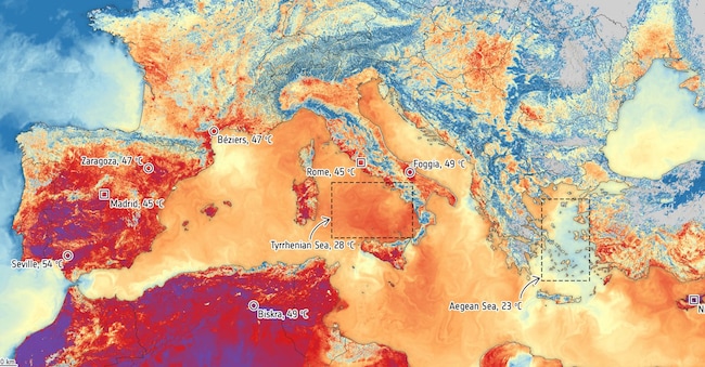
This is revealed by an image released by Esa, the European space agency, depicting a mosaic of five overlapping orbital passes on the morning of 29 June 2025. An image acquired by the Sea and Earth Surface Temperature Radiometer of the Copernicus Sentinel-3 mission. As the name suggests, the radiometer is capable of measuring the temperature of the sea and land. As the name of the instrument suggests, the image reveals the temperature of the earth's surface, not that of the air. Unlike air temperature measurements, this satellite instrument measures the actual heat energy emitted by the earth's surface, which generally records higher temperatures than air temperatures.
In fact, it is not only the surface of the earth that is warm, but also the sea surface of the Mediterranean Sea, as the image using information from the Copernicus Marine Service shows. Monitoring the earth's surface temperature is crucial for understanding and predicting weather and climate patterns, monitoring fire risk, supporting farmers in irrigation planning and guiding urban design to better mitigate heat.
The current heat wave is driven by a high pressure system stalled over western Europe, commonly referred to as the 'heat dome'. This system acts as a lid, trapping warm, dry air and amplifying temperatures over time. Moving eastwards, it is also drawing in additional warm air from North Africa, further exacerbating extreme heat across the region.

