Weather

Christmas with snow, rain and wind: red alert in Emilia-Romagna

Low altitude snowfall and widespread rain, with intense wind. Worsening conditions in the Ravenna area, evacuations ordered

Aggiornato il 25 dicembre 2025

La bufera di nevea Prato Nevoso, nel Cuneese.  ANSA/SCUOLA SCI SNOW ACADEMY PRATO NEVOSO

5' min read

Translated by AI
Versione italiana

5' min read

Translated by AI
Versione italiana

It will be a White Christmas in the mountains with bountiful snowfalls above 600-700 metres in the North and on the Tuscan-Emilian Apennines, above 1000-1200 metres on the rest of the ridge. Wind and heavy rain are expected over the rest of Italy. But for the last weekend of the year, the sun will return. This is confirmed by Lorenzo Tedici, meteorologist in charge of media at iLMeteo.it. "Until Thursday morning," he says, "the regions reached by the heaviest rainfall will be those of the North-West and those of the Tyrrhenian belt. During the afternoon we will still have open umbrellas in the Centre-North and snow on the North-Western Alps and Northern Apennines, with only a few isolated phenomena in the extreme South".

The wind will be strong at times with an abnormal situation even in the Po Valley and will sweep away the smog. By Boxing Day the weather will still be unstable but improving and the last weekend of the year will be sunny.

Loading...

In detail: at Christmas, in the North: widespread rain in the North-West, snow in the mountains at low altitudes. In the Centre: unstable weather in Tuscany, Lazio and Marche; snow in the Apennines. In the South some rain especially on the Ionian coast. Friday 26, in the North, improvement. In the Centre, unstable weather with a few showers on the Adriatic areas. In the South, some rain especially in Sardinia and on the Ionian strip. Trend: high pressure returns with sunshine, but it will gradually get colder.

Natale, in Italia arrivano freddo e neve a bassa quota

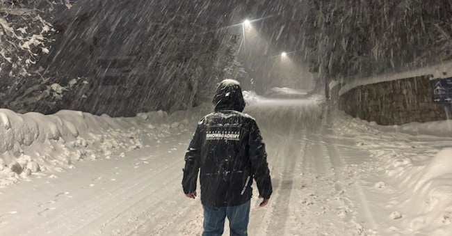
Christmas in the snow in the Aosta Valley

Snow coming on Christmas Day in Valle d'Aosta. According to the forecasts of the regional meteorological office, on 25 December the sky will be "very cloudy or overcast for the whole day, with some partial clearing only on the mountains on the Swiss border". Widespread and moderate rainfall is expected in the eastern sector, weak and less continuous in the rest of the region, intermittent at times, with snowfall limits at around 600 metres above sea level". On Boxing Day "until around 8.00 a.m., it will still be very cloudy with residual very weak and scattered snowfalls, then dry and clouds will decrease starting from the mountains on the border with Switzerland, with clear or slightly cloudy skies everywhere from the end of the morning". From Saturday "stable weather, mostly clear, dry skies, temperatures rising until Sunday, then falling from Monday".

Red alert in Emilia Romagna

Red alert on Christmas Day in Emilia Romagna, a region over which widespread and persistent rainfall is expected, especially in the central sector. According to the bulletin issued by the Regional Weather Alert, due to the bad weather conditions, widespread landslide phenomena may be generated, runoff along the slopes and rises in the hydrometric levels in the watercourses with exceedings of threshold 2. Maximum alert in particular on tributaries to the right of the Rhine with hill feeding.

On the Apennine and hilly sectors of Emilia Romagna, the phenomena will be snowy starting from altitudes around 300/400 metres, with accumulations of 5-15 cm on the hilly areas and a further 20-30 cm on the mountainous areas. Along the coastal strip, moderate gale-force winds (62-74 km/h) from the north-east are also forecast, with strengthening or gusts of higher intensity, with rough seas, localised erosion phenomena on coastlines, dunes and winter banks, as well as sea inundations that may affect bathing establishments. Flooding of rivers and canals at their mouths will also be possible, due to the difficulties of flood discharge into the sea.

Worsening conditions in Ravenna, evacuations ordered

Also in Emilia Romagna, the first evacuations have occurred due to the bad weather. Of particular concern is the flooding of the Senio river in the province of Ravenna, which has led the local authorities to issue an evacuation order. In Castel Bolognese, the municipality has invited those affected to go to the palasport, which has been chosen as a point of assistance and support. The mayor, after an extraordinary meeting with the Prefecture, reports that the river conditions are rapidly worsening. At 5 p.m., the sensor in Casola Valsenio indicated that the yellow threshold had been exceeded and was rising. At Tebano, the river level has exceeded the red threshold with a level of 5.76 m. At Ponte del Castello at the moment the gauges indicate that the orange threshold has been exceeded with a value of 5.27 m. "It is important to maintain a high level of attention, avoid moving and keep up to date on the official channels of the municipality. We remind you that it is absolutely forbidden to approach the river banks".

Black dot on A22 from Boxing Day to 29 December

black marker on the Brenner motorway from Friday to 29 December in the direction of Bolzano. This is stated in the traffic forecast plan prepared by the motorway company on the occasion of the Christmas holiday exodus. In the event of bad weather and snow, the A22 can count on 424 operational vehicles for salt spreading and snow removal, 13,520 tonnes of salt fluxes and 1,225 tonnes of liquid salt solution, which are used when the 26 weather stations and the sensors in the road surface make the thermal mapping of the motorway sections come into operation.

Bora in Trieste, gusts up to 120 km/h

Trieste woke up lashed by a strong Bora wind that began blowing last night and will continue until tonight or even tomorrow, according to the forecast. The Trieste coast is the worst affected. The gusts, cold, are travelling at speeds of 100 and even 120 kilometres per hour. The Bora is associated with rain and a drop in temperatures both in the city and in other areas of the region, including the mountains. The usual inconveniences caused by the strong gusts are also appearing, such as dehors falling outside premises, as well as parked scooters and motorbikes. If the materials in the yards have been prudently anchored, some Christmas decorations, on the other hand, have flown off, torn from private homes and public establishments.

Prot. Civ. Campania, after rains attention to hydrogeological risk

"The Civil Protection of the Campania Region, in light of the rainfall in recent hours, in view of the current weather picture and the assessments of the Functional Centre, recommends to pay attention to phenomena related to hydrogeological risk, even in the absence of new rainfall". This was read on the Campania Region's Facebook page. "For this reason," it goes on to say, "the Region of Campania has extended the current yellow weather alert for thunderstorms in zones 1 and 3 (1 - Campania Plain, Naples, Islands, Vesuvian Area; 3 - Sorrento-Amalfitan Peninsula, Sarno Mountains and Picentini Mountains) until 6 p.m. tomorrow, Thursday 25 December. In fact, a 'residual risk' is expected, which could still bring runoff, possible rock falls and landslide phenomena in view of the saturation of the soils, despite the absence of precipitation'.

"The weather alert - continues the post of the Region - is in force until 6 tomorrow morning, for showers and thunderstorms also intense, as well as for strong winds, on the areas of alert: 1 - Plain Campana, Naples, Islands, Vesuvius Area; 2 - High Volturno and Matese; 3 - Sorrento-Amalfitan Peninsula, Sarno and Picentini Mountains; 5 - Tusciano and Alto Sele; 6 - Plain Sele and Alto Cilento; 8 - Lower Cilento. The extension of the Gialla criticality, on the other hand, will be triggered at 6 a.m. tomorrow morning only for zones 1 (Piana Campana, Naples, Islands, Vesuvius Area) and 3 (Sorrento-Amalfitana Peninsula, Sarno Mountains and Picentini Mountains). Municipalities in the affected areas are reminded to keep their COCs (Municipal Operations Centres) active and to put in place all structural and non-structural measures to prevent, counteract and mitigate the expected phenomena, in line with their respective municipal civil protection plans. Please monitor public green areas, in view of the wind alert that is also affecting the territory, and ensure the proper sealing of structures exposed to wind and wave stress. Please pay attention to the communications of the Regional Operations Room'.

Copyright reserved ©
Loading...

Brand connect

Loading...

Newsletter

Notizie e approfondimenti sugli avvenimenti politici, economici e finanziari.

Iscriviti