Seismic monitoring

Earthquakes in the Tyrrhenian Sea: how and why they occur

Movements of the tectonic plates and volcanic activity: how earthquakes occur in the Southern Tyrrhenian Sea and how they differ from those in the Phlegraean Fields

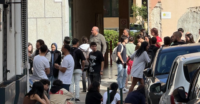
Gente in strada dopo le tre scosse di terremoto. La più forte è stata di magnitudo di 5.5 con epicentro nel Tirreno meridionale a nod-ovest delle Eolie, non distante da Alicudi. Al momento non ci sono state segnalazioni grossi danni.Palermo,23 ottobre 2026. (Ansa)

3' min read

Translated by AI
Versione italiana

3' min read

Translated by AI
Versione italiana

Between 20 and 24 October, a series of earthquakes struck the southern Tyrrhenian Sea, approximately 30 km north-west of Alicudi, one of the Aeolian Islands. The event with the highest magnitude, 5.0 , occurred on 23 October at 12.19.

It was the residents of the archipelago and the northern coast of Sicily who felt the tremor most strongly; it was, however, less severe in the rest of Sicily and in Calabria.

Loading...

The National Seismic Monitoring Service of the INGV (National Institute of Geophysics and Volcanology), which monitored the swarm, stated that the earthquake on 23 October was one of the strongest recorded in the area in the last 46 years, second only to the magnitude 5.2 earthquake of 28 May 1980.

According to the latest estimates from the INGV on the morning of 28 October, the sequence comprised around 220 events following the main earthquake.

“HAI SENTITO IL TERREMOTO?”

Mappa preliminare delle intensità macrosismiche (MCS) stimate nei Comuni tramite i questionari inviati al sito «Hai sentito il terremoto?» a seguito del terremoto di magnitudo 5.0, a cura dell’Ingv.

Loading...

Movements in the Southern Tyrrhenian Sea

But what movements cause these earthquakes? When seismic events occur in the Tyrrhenian Sea – where, since 1985, they have been recorded frequently, many with a magnitude greater than 4.0 – people tend to think of Marsili, the largest underwater volcano in the Mediterranean and in Europe.

Yet, as the INGV reports in one of its articles, the Marsili is characterised by ‘hydrothermal activity and very low-energy seismic activity’.

No direct correlation can be found for two other factors either: the 20 km distance between the volcano and the area affected by the seismic sequence of recent days, and the discrepancy between the extensional volcanism of Marsili and the compressional source that characterised the earthquake on 23 October.

Salvatore Stramondo, the head of the Earthquake Department at the INGV, explains that the Tyrrhenian Sea, particularly its southern part, is affected by three main seismic sources: 1) crustal sources; 2) deep sources; 3) volcanic sources.

Whilst underwater volcanic eruptions can be ruled out in this case, the characteristics of the deep-sea vents do not match those of the October tremors either.

Earthquakes of this type can have a hypocentral depth of between 400 and 600 km and are caused by the subduction of the Ionian plate beneath the Calabrian arc: the plate gradually descends to a depth of hundreds of kilometres, until it reaches the lithosphere and collides with it.

Loading...

The October event, on the other hand, was a crustal seismic sequence, caused by an accumulation of energy generated by the continuous northward movement of the African plate along its boundary with the Eurasian plate.

Stramondo points out that, whilst seismic zones are well known and monitored, the timing – that is, when the next earthquake will occur – cannot yet be predicted.

The Phlegraean Fields

Meanwhile, the Phlegraean Fields recorded further tremors on Tuesday 27 October – albeit minor ones – following the swarm of tremors with a magnitude of 4.4 last May. ‘It is important to remember that the Phlegraean Fields are a volcanic area, one of the highest-risk areas in the world,’ emphasises Stramondo. “It is an active area: the ground is rising due to gases heated by the magma beneath. Furthermore, the risk – which is the product of hazard, vulnerability and exposed value – is due to the presence of numerous homes and infrastructure on the surface of the area in question.”

As for the ever-present fear of a possible eruption of Vesuvius, Stramondo reassures us that ‘Italy’s volcanoes are the best monitored in the world’, thanks to a system that provides benchmark parameters. Furthermore, consulting past reports makes it possible to identify potential warning signs and activate any necessary alert measures.

Copyright reserved ©
Loading...

Brand connect

Loading...

Newsletter

Notizie e approfondimenti sugli avvenimenti politici, economici e finanziari.

Iscriviti