Weather

Bad weather: orange alert (the highest level) issued for thunderstorms in Liguria and Tuscany

Severe weather is forecast for some areas in the north, and is expected to affect parts of central Italy between Thursday 20 and Friday 21 August

aggiornamento ore 13:50

Aggiungi Il Sole 24 Ore
ai preferiti su Google
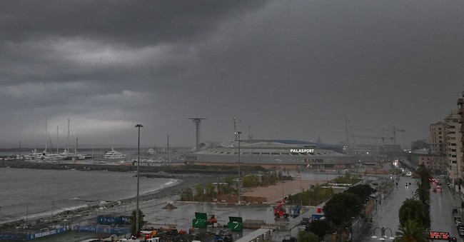
Prime piogge in Liguria, dopo la lunga estate torrida, con allerta di livello giallo in quasi tutta la regione. Genova, 20 agosto 2026.  ANSA/LUCA ZENNARO

5' min read

Translated by AI
Versione italiana

5' min read

Translated by AI
Versione italiana

Bad weather and more thunderstorms, whilst the weather alert has been raised from yellow to orange: this is the forecast issued by Arpal, the regional meteorological and hydrological centre, for the coming hours in Liguria. Following an initial spell of unsettled weather with heavy rain and downpours affecting the Tigullio area, east of Genoa – with rainfall peaks reaching 103 mm this morning as measured by the rain gauges in Chiavari – the second phase of the weather system affecting the whole of northern Italia has led forecasters to update the alert status.

Following the yellow alert, which has been in place since this morning, from 3 am tonight until 3 pm tomorrow, the alert will be upgraded to orange, the highest level for thunderstorms, covering the north-eastern parts of Liguria and the eastern slopes of the Po Valley, before reverting to yellow until 5 pm tomorrow. The yellow alert has been extended to the far west and the western slopes of the Po Valley from 3.00 pm today until 3.00 pm tomorrow.

Loading...

Conditions of severe instability persist across Liguria. This morning, a very intense thunderstorm affected the Tigullio area; throughout the morning, several thunderstorm cells developed within a line of instability that crossed our region.

A loud bang, followed by a power cut affecting the control and safety systems. A bolt of lightning, after striking a pole, is believed to have caused a sudden electrical surge inside the Ventimiglia railway station, causing chaos in the control room and resulting in the loss of control over rail traffic. The station is at a standstill: no trains are departing or arriving. The control and safety systems have failed, and technicians are working to restore normal operations. An initial intervention only allowed a train carrying passengers, which was already approaching the station, to enter the station. Otherwise, services remain suspended and it is not yet known how long it will take to fully restore them.

An orange alert for severe thunderstorms has also been issued by the regional civil protection operations centre for central and northern Tuscany, from 10.00 pm today until 6.00 pm tomorrow, Friday 21 August , with a yellow alert in place for the rest of the region tomorrow. The President of Tuscany, Eugenio Giani, announced this on social media, adding that a yellow alert has been issued for flood risk affecting the main river network in central Tuscany and the Lunigiana area tomorrow. “Our Civil Protection system,” adds Giani, “is operational and ready to intervene if necessary; let’s remain vigilant and exercise caution! Conditions are expected to worsen, with the possibility of severe thunderstorms in the north-western areas, particularly from this evening. Tomorrow, Friday, heavy thunderstorms are expected to spread from the north-west to the rest of the region. Strong gusts of wind and hailstorms associated with the thunderstorms are likely. Maximum cumulative rainfall of up to 70–100 mm and locally up to 150 mm. Hourly rainfall intensity of up to 60–80 mm.”

Bad weather and a drop in temperatures in the north; flooding in the Genoa area. Intense heat in the south

Italia is bracing for a spell of severe weather in the north, which is set to affect parts of central Italy between Thursday 20 and Friday 21 August, whilst in the south the heat will remain intense and is set to rise again over the weekend.

According to the forecast by Lorenzo Tedici, the meteorologist in charge of media relations at iLMeteo.it, the weather system will move slowly from the north-west towards the east and could bring very heavy rainfall, with accumulations exceeding 200 millimetres between Lake Como and Valtellina.

The arrival of cooler air follows a long spell dominated by hot weather. Tedici dates the start of the season’s first heatwave to 24 May and highlights how the atmosphere has built up a great deal of energy, whilst sea temperatures along the Italian coast have reached particularly high levels, with peaks of 29–30 degrees even in the Ligurian Sea and the northern Adriatic. The contrast with the influx of cooler air may lead to intense thunderstorms and hailstorms.

The spell of unsettled weather is expected to last around 48 hours. Between Thursday and Friday, thunderstorms will affect the north and may extend to northern Tuscany and other parts of central Italy. In the north, a sharp drop in temperatures is also expected: maximum temperatures are likely to fall to around 27–28 degrees and, in some places, below 25.

The situation is more varied in the Centre. In Rome, the hot weather is set to continue, with maximum temperatures of around 34 degrees, whilst in Florence, cooler temperatures of around 30 degrees are forecast for next week.

Loading...

The South , on the other hand, will remain on the fringes of the weather system and will continue to experience very hot air.

Caldo record, raccolto di cereali in calo

Over the weekend, temperatures could exceed 38–40 degrees in Puglia, Campania, Basilicata and Calabria. In Sicily, peak temperatures of close to 41 degrees are forecast, with intense heat which, according to current forecasts, could persist until the first few days of September.

On Thursday 20 August, bad weather will move across the north from west to east, whilst in the centre, thunderstorms are expected mainly from the evening onwards; in the south, sunny conditions and rising temperatures will prevail.

On Friday, the weather will remain very unsettled in the north, particularly in the morning, with scattered showers and thunderstorms also affecting central Italy, whilst the south will remain sunny and warm.

On Saturday, conditions are expected to improve in the north, although there will be some isolated showers, whilst conditions will be more stable in central Italy.

In the south, sunny and hot conditions will continue. Sunday is expected to bring mainly fine weather, with possible spells of unsettled weather still confined mainly to the northern regions and high temperatures in the southern regions.

Germany: Tree falls during a storm in Waldorf; one woman dead and another injured

One woman has died and another has been seriously injured after a tree fell on them in Waldorf, in the western state of Rhineland-Palatinate, 50 kilometres south of Cologne, due to severe storms which caused extensive damage in various parts of Germany overnight. According to police reports, the two women, aged 58 and 47, were out walking together in Waldorf, in the western state of Rhineland-Palatinate, about 50 kilometres south of Cologne, when the storm hit the area and they sought shelter under a canopy. A nearby tree was uprooted by the storm and fell onto the canopy, striking both women. The 58-year-old died at the scene, a police spokesperson said, whilst the 47-year-old was taken to hospital with serious injuries.

Emergency operations linked to bad weather have also been reported in the states of Hesse, Thuringia, Brandenburg and Bavaria.

Copyright reserved ©
Loading...

Brand connect

Loading...

Newsletter

Notizie e approfondimenti sugli avvenimenti politici, economici e finanziari.

Iscriviti