
The US National Weather Service: El Niño has begun in the tropical Pacific
The phenomenon consists of a periodic warming of the surface waters of the central-southern and eastern Pacific, which occurs every 2 to 7 years. It lasts between 9 and 12 months
Key points
El Niño is officially back: the US National Oceanic and Atmospheric Administration (NOAA) has announced that the phenomenon has developed in the tropical Pacific Ocean. This appears to confirm the predictions made by the World Meteorological Organisation (WMO) in its ‘Global annual-to-decadal update’ report, which forecast its arrival by the end of 2026. Precisely for this reason, the WMO considers it possible that 2027 will take the place of 2024 as hottest year on record in Italia.
What is it?
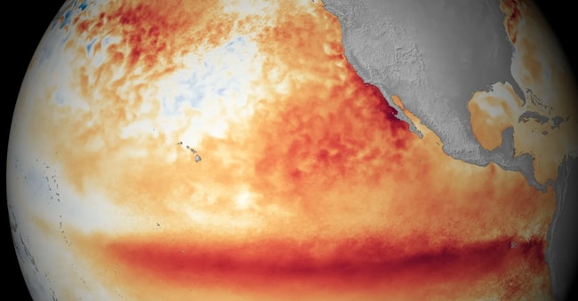
El Niño is a periodic warming of the surface waters of the central-southern and eastern Pacific, off the coast of Latin America, which occurs every 2–7 years. The rise in temperature ranges from 0.5 to 3 degrees. The NOAA announces the onset of this meteorological phenomenon when the temperatures of the waters of the equatorial Pacific Ocean are 0.5 degrees above average for several consecutive months.
El Niño usually lasts between 9 and 12 months. Together with its corresponding cooling phase – which, by analogy, is known as La Niña – it forms the ENSO (El Niño-Southern Oscillation). The phenomenon tends to be strongest during the winter months and its effects are most noticeable in the northern hemisphere. In fact, according to the World Meteorological Organisation, the most recent significant event peaked between late 2023 and early 2024.
Possible developments
According to forecasts, El Niño is set to intensify this autumn, reaching a level classified as ‘moderate’ or ‘strong’. Meteorologists estimate there is a 63% probability that sea surface temperatures will exceed 2.0 degrees in the area affected by the phenomenon. And, if this threshold is exceeded, the event is classified as “very strong”.
“Not all El Niño events are the same; each one is unique and leaves its own mark on our climate. Advanced monitoring and a better understanding of El Niño patterns enable the NWS to better forecast and prepare the public and our key partners for what lies ahead,” explained Ken Graham, director of the National Weather Service (NWS) at NOAA.

